Best Orange County Hikes

Hikes In Orange County
There is an Orange County hiking trail for everyone, from tough mountain hikes, to hidden waterfalls, to pristine coastal hikes with ocean views. Cleveland National Forest in the east is a vast treasure trove of primitive hikes away from the malls and developments in Orange County. Because the area is somewhat affluent, the Orange County Parks Department is one of the best in the USA. And if you just need an easy hike to reconnect with nature, a beach hike is easy enough and requires little preparation.
Best Orange County Hikes
- Crystal Cove State Park
- Saddleback Mountain (Santiago Peak)
- Laguna Coast Wilderness Park
- Whiting Ranch Hiking: Red Rock Canyon
- Sitton Peak
Best Orange County Hikes For Families
- Bolsa Chica Ecological Reserve Hike
- Dripping Cave
- Quail Hill
- Hike Holy Jim Falls Trail
- Whiting Ranch Hiking: Red Rock Canyon
- Peters Canyon Hike
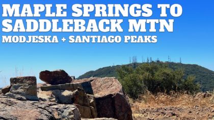
Hike Santiago Peak & Modjeska Peak From Maple Springs
If you want to bag both peaks of Saddleback Mountain, Modjeska and Santiago, the route from Maple Springs is a great option. In this guide I’ll show you how to park at the end of the paved road and then hike through the heart of the Santa Anas to the summits. The first few miles of the hike are on a dirt road, but then we’ll switch onto rugged singletrack. There’s a lot of confusion around hiking this route, and this guide should clear it all up and make it easy.
Silverado, CA - 16 miles, Hard
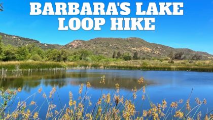
Barbara’s Lake Hike (Laguna Beach)
This easy hike to Barbara’s Lake, one of Orange County’s only naturally occurring lakes, is well worth a go. While close to suburbia, the lake lies within the James Dilley Greenbelt Preserve, an island of natural beauty where the land looks as it did hundreds of years ago. This guide will show you a pleasant loop that takes you to the lake, up a small climb, and then back along a ridge offering expansive views. You can also hike to Barbara’s Lake and turn around for a shorter experience.
Laguna Beach, CA - 2.9 miles, Easy
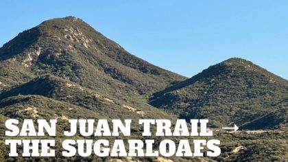
San Juan Trail to Sugarloaf Peaks
Yes, more Sugarloaf Peaks. We have a pair of them this time, and they’re in Cleveland National Forest. This challenging route on the popular San Juan Trail, once a native path traversing the Santa Anas, brings you to Old Sugarloaf and (new) Sugarloaf, which you can bag and enjoy some great views in the process. It’s a challenging hike into a remote section of this rugged and underrated area.
Lake Elsinore, CA - 13.9 miles, Hard
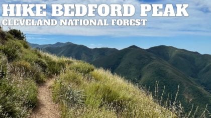
Hike the Bedford Peak Trail (Orange County)
If you’re looking for a hidden gem, the Bedford Peak Trail is for you. You’ll get an excellent workout climbing about 2000 feet in 3 miles, and at the top, you have gorgeous views of the Santa Anas, Angeles National Forest, Catalina, and on a clear day, the higher peaks of SoCal. Overall it’s an underrated gem.
Silverado, CA - 7.2 miles, Hard
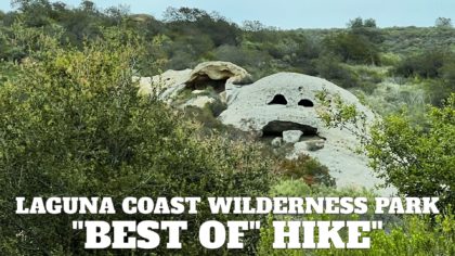
Laguna Coast Wilderness Park Hike
Laguna Coast Wilderness Park is a real gem in Southern California. Its 7000 acres of protected land are one of the last bastions of coastal wilderness. This park is what Orange County coast looked like before man started developing here. You’ll enjoy pristine coastal sage scrub, ridges with panoramic views, wildlife including over 40 endangered species, and some unique ecology. The park has over 40 miles of trails, and this loop of 7.6 miles is what one park ranger once laid out for me as the “best of ” loop, giving you a taste of everything the park has to offer.
Laguna Beach, CA - 7.5 miles, Moderate
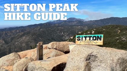
Sitton Peak Hike
Although not one of the high peaks of Cleveland National Forest, Sitton Peak is one of the more popular ones to bag. The hike to Sitton Peak is challenging but not too harsh, and at the top, you are treated to panoramic views from Catalina to the SoCal high peaks. You’ll also get to explore the San Mateo Wilderness, a protected area of unique and lush chaparral, oak woodlands, and coastal sage.
Trabuco Canyon, CA - 9.6 miles, Moderate
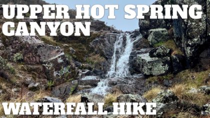
Upper Hot Spring Canyon Waterfall Hike
Tucked away in a remote corner of Cleveland National Forest, the waterfalls of Upper Hot Spring Canyon are truly wild and beautiful. Luckily it’s a relatively easy hike to the first 15-foot waterfall, then a bit harder to the second, taller 25-foot waterfall, which I cover in this guide. After that point, this hiking guide ends because Lower Hot Spring Canyon lacks a trail and is known as one of the most challenging canyoneering routes in SoCal. But this more leisurely hike in the upper canyon will give you a taste of the beauty without having to mount a major expedition.
Lake Elsinore, CA - 2.8 miles, Moderate
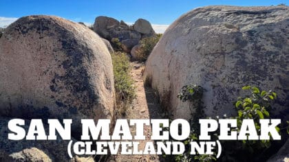
Hike San Mateo Peak (Cleveland National Forest)
San Mateo Peak, a beautiful and fun hike with a fantastic summit and sweeping views, is not officially there. The trail is not on the Forest Service maps, and you won’t find “San Mateo Peak” anywhere on an official topographic map. But the trail and peak are there all right, and in this guide, I’ll show you how to hike to the top and enjoy this fun peak in Cleveland National Forest.
Lake Elsinore, CA - 4.6 miles, Moderate

Tin Mine Canyon Trail Guide
Hiking the Tin Mine Canyon Trail takes you into another world. You’ll park your car in suburban SoCal, but end up in a lush, shaded gully alongside a mountain stream. On the way you get to check out the old tin mine shafts, over 100 years old and once part of the search for the purest tin in the world. The Tin Mine Canyon Trail is relatively short, easy, shaded, and great for the family.
Corona, CA - 5 miles, Easy
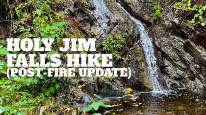
Hike Holy Jim Falls Trail
Tucked away in a hidden canyon in Cleveland National Forest, the hike to Holy Jim Falls is fun, easy, and great for families. The area recovering from the 2018 Holy Fire is still very lush and offers forest and tree cover not often found in Southern California. You’ll hike up a gentle gradient along Holy Jim Creek and then turn off onto the Holy Jim Falls spur trail, which narrows as it approaches the falls.
Corona, CA - 3.4 miles, Easy
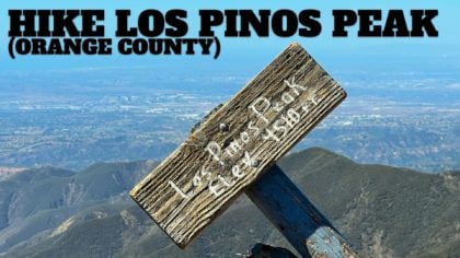
Hike Los Pinos Peak (Orange County)
The hike to Los Pinos Peak offers a remote and rugged experience through the heart of Cleveland National Forest. Although not technically prominent, Los Pinos Peak is “practically” prominent, and on the hike, given a clear day, you can see from Catalina to San Gorgonio. There are several ways to hike to Los Pinos Peak, and in this guide, I’ll show you the most popular (and shortest) route from the area by Falcon Group Campground.
Lake Elsinore, CA - 5.4 miles, Moderate
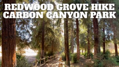
Redwood Grove Hike Guide (Carbon Canyon – Brea)
It’s an easy hike to visit Southern California’s largest Redwood Grove, located in Carbon Canyon Regional Park. The Redwood grove, while not as majestic as those in Northern California, is still impressive. You’ll be able to wander in the shade of over 200 Redwoods, which would not survive in the hot, dry Southern California climate without the loving attention of OC Parks. It’s a great hike that’s easy for families and beginners.
Brea, CA - 1.5 miles, Easy
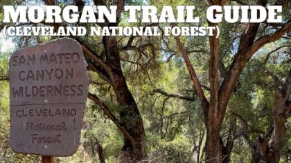
Morgan Trail Hike (Cleveland National Forest)
Hiking the Morgan Trail takes you on a serene journey through the rugged San Mateo Canyon Wilderness, off the beaten path and away from the hustle and bustle of other nearby and popular trails. You’ll hike through the chaparral with high peaks of the Santa Anas flanking you until you reach scenic and shaded Morrell Canyon, full of willows, sycamore, and oaks. And at the end of the Morgan Trail, you’ll be treated to epic views of Lake Elsinore and the high peaks of Southern California.
Lake Elsinore, CA - 10.5 miles, Moderate
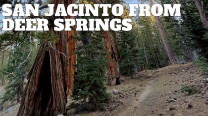
Hike Mt San Jacinto Peak on the Deer Springs Trail
The hike to Mt San Jacinto Peak on the Deer Springs Trail is one of the toughest and most beautiful hikes in Southern California. You’ll climb over 5000 feet on the ascent of San Jacinto Peak, hiking through old-growth pine forests until you crest the summit. On the way back down, we’ll hike the Wellman’s Cienega Trail, which hugs the mountainside, offers incredible views of Tahquitz Peak and Lily Rock, and feels more like Yosemite than Southern California. You can tackle this underrated hike in one day or break it up overnight in Little Round Valley Campground.
Idyllwild, CA - 19 miles, Very Hard
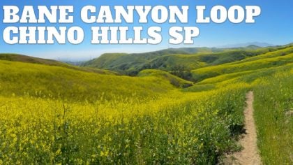
Bane Canyon Loop Trail – Chino Hills State Park
Bane Canyon, located in Chino Hills State Park, comes alive with flowers in the spring. In this moderate loop hike, you’ll leave the crowds behind and circle picturesque Bane Canyon. Along the way, you’ll enjoy the landscape of Chino Hills, views of the high mountains, and hopefully, lots of colorful flowers. It’s a fun hike that’s doable by most folks in decent shape.
Chino Hills, CA - 8 miles, Moderate
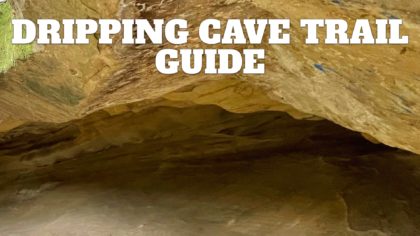
Dripping Cave Trail Hike
Tucked away in Aliso and Wood Canyons Wilderness Park, just minutes from Laguna Beach, the Dripping Cave Trail is one of the most fun and easiest hikes in Orange County. Dripping cave, used by native peoples and later bandits, is huge, open, and fun to explore. The park is rich with natural beauty and wildlife, and on the way to Dripping Cave, we’ll visit Cave Rock, another cool rock formation hidden away from the busier trails. This five-mile hike is mostly flat, easy to follow, and family-friendly.
Aliso Viejo, CA - 5 miles, Easy
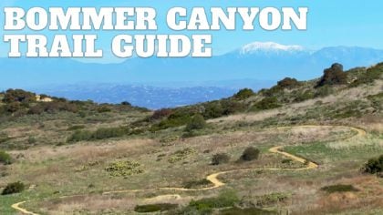
Bommer Canyon Trail Hike Guide
The Bommer Canyon Trail, a natural oasis nestled within suburbia, offers a little bit of everything. This easy hike showcases natural beauty, has lots of wildlife spotting opportunities, an interesting history, and sweeping vistas as you approach the highest point in the San Joaquin Hills. The full 4.8 mile hike includes some uphill, but if you want to do something easy, I’ll show you an easy 2 mile option that’s flat and great for families. Bommer Canyon is a National Natural Landmark and California’s first Natural Landmark; it’s worth visiting.
Irvine, CA - 4.8 miles, Moderate
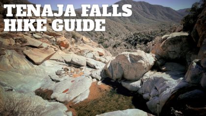
Tenaja Falls Trail Guide
Nestled deep in the remote San Mateo Canyon Wilderness, the Tenaja Falls Trail takes you to majestic Tenaja Falls, a cascading waterfall that plunges 150 into the scenic canyon. In this guide I’ll show you two ways to get to the falls. You can either do the short 1.5 mile (total) “roadside attraction” route, or you can take the 7.5 mile scenic and relatively easy route through Fisherman’s Camp and along San Mateo Creek. Which ever way you go, you’re in for a treat, because the scenery is incredible and the vibe is off the beaten path.
Murrieta, CA - 7.5 miles, Moderate
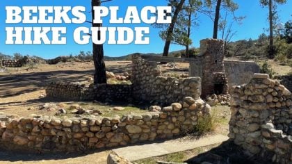
Beeks Place Hike From Black Star Canyon
The Beeks Place hike takes you to the ruins of an old cabin compound built at a scenic spot high in the Santa Ana Mountains. From Beeks Place, you can see from San Gorgonio to Mt Baldy to Catalina. The hike is challenging, taking you 2000 feet up fire roads through the mountains, and along the way, you get epic views, hidden pastures, and even a Native American settlement. While Beeks Place might not be a big-name peak bagging experience, it is a nice long mountain hike that you can do all year.
Silverado, CA - 16 miles, Hard
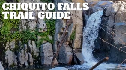
Hike the Chiquito Falls Trail
Nestled deep in Cleveland National Forest, the Chiquito Trail takes you away from the crowds visiting the popular San Juan Falls to a waterfall hidden in a secluded canyon up in hills, Chiquito Falls. To get there you have to hike up a moderate climb, but as with most climbs, you’re rewarded with great views. The hike to Chiquito Falls is great for the hiker who’s done the popular trails and now wants something a little different without the bigger crowds (like nearby Sitton Peak).
Lake Elsinore, CA - 9.6 miles, Hard
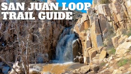
San Juan Loop Trail Guide (CA)
The San Juan Loop Trail by Lake Elsinore is a fun hike that offers an easy glimpse into the Cleveland National Forest’s rugged beauty. You’ll hike to Ortega Falls, a 35-foot waterfall in a steep ravine, and then you’ll meander through lush canyons rich with wildflowers in the spring. The trail also follows San Juan Creek, which usually has water in the spring and early summer, and eventually drains out to the ocean. Overall the San Juan Loop Trail is a great family or beginners hike that packs a lot of scenery into a short distance.
Lake Elsinore, CA - 2.1 miles, Easy
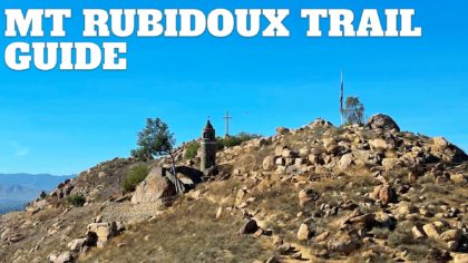
Hike the Mt Rubidoux Trail (Riverside)
Although not a wilderness hike, the Mt Rubidoux Trail, nestled right in the middle of Riverside, CA, still has lots to offer and is worth a visit. A gradual, paved, family-friendly trail winds up to the top of Mt Rubidoux, where you are treated to panoramic views of the big mountain ranges, as well as attractions some historical attractions like the Serra Cross, the giant flag, and the Peace Bridge. Now there are many trails in Mt Rubidoux Park, but I’ll show you the popular (and probably easiest) route to the top.
Riverside, CA - 3 miles, Moderate
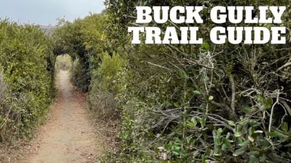
Buck Gully Trail Guide
The Buck Gully Trail is a peaceful and fun hike through a coastal watershed located in Newport Beach’s foothills. What makes the hike remarkable is that the 1,200 acres of Buck Gully Reserve are tucked in between all the development around Newport Beach. So even though this hike is close to civilization, you feel like you are a world away as you hike your way up the canyon. It’s an easy hike, great for all levels and families. And while the trail itself doesn’t offer ocean views, I’ll show you an optional loop that offers vistas to Palos Verdes and Long Beach.
Corona Del Mar, CA - 5.2 miles, Easy
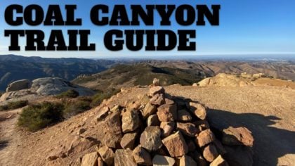
Hike Coal Canyon Trail
Don’t let the start of the Coal Canyon Trail, which is next to the 91 freeway, fool you. After a short stretch next to the freeway on the Santa Ana River Trail, you’ll hop into a wildlife corridor and up into the northwest Santa Ana Mountains. Along the way, you’ll have views of Angeles National Forest, San Gorgonio, and at the top, Orange Counties’ “Mini-Moab.” It’s a bit of an under-hiked gem, so get out and enjoy it.
Corona, CA - 10 miles, Moderate
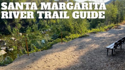
Santa Margarita River Trail
The Santa Margarita River Trail hike is a true gem. The hike follows the shady shores of the Santa Margarita River, Southern California’s last undiverted, free-flowing river, home to over a hundred species of animals. The peaceful river banks also hold glimpses into the area’s past, including Native American artifacts and relics of a railroad that once connected San Diego to the outside world. Today the Santa Margarita River Trail is protected and well-marked thanks to the non-profit Wildlands Conservancy. It’s a beautiful trail that’s easy, with a flat 3 mile option or a longer 5.7 hike to a hidden beach.
Fallbrook, CA - 5.7 miles, Moderate

Best Orange County Hikes With Dogs
Orange County is home to hundreds of miles of great trails and hikes you can do with dogs. There’s everything from mountains to beaches, and this guide has some dog owner’s favorites. You can see a complete list of all hikes for dogs in Orange County here, but these are the top picks.
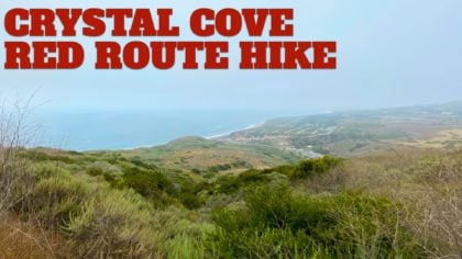
Crystal Cove Red Route Hike
The Crystal Cove red route is the toughest hike that the park recommends, calling it “a strenuous loop hike around the permitter of the park.” The hike doesn’t include a big mountain climb, but rather is a series of ups and downs through pristine native coastal scrub, a rarity in Southern California. The red route is well marked and easy to follow, there are bathrooms along the way, and it offers lots of opportunities for wildlife spotting and expansive ocean views.
Laguna Beach, CA - 9.2 miles, Hard
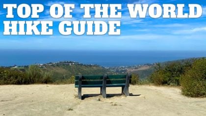
Top of the World Hike (Laguna Beach)
There are big payoffs on the short but steep Top of the World hike in Laguna Beach. You’ll climb through the coastal scrub of Aliso and Wood Canyon Wilderness Park until you reach the panoramic vista at Top of the World. From there, you’ll have views from Catalina Island to Mt Baldy, and there’s even a bench where you can soak it all in.
Laguna Beach, CA - 2.4 miles, Hard

Car Wreck Trail (Laguna Beach)
Hidden in the hills high above Laguna Beach, far away from any road, lies the fabled “car wreck,” 1946 Dodge 5-passenger coupe. Visiting the car wreck became so popular that Aliso and Wood Canyons Wilderness Park officially made a trail to it in 2013. Today it’s a fun hike, offering not only a cool vintage car wreck but also expansive views from Catalina to Mt Baldy. This guide has a 3.8 mile loop that makes the climbing a little easier, or you can do a shorter hike to the car wreck and back.
Laguna Beach, CA - 3.8 miles, Moderate

Weir Canyon Loop Trail Hike
The Weir Canyon Loop Trail hike is tucked into Orange County suburbia, but once you step onto the trail, you will feel like you are miles away. This scenic loop trail in the foothills of the Santa Ana Mountains is packed with scenery. It offers stunning panoramic views reaching to the high mountains, easy to follow trails, winding canyon paths, and lots of wildflower and wildlife viewing. The full hike is 3.8 miles but you can do it with 1.5 or 2.5 mile options too. It’s a great hike for families and those just wanting an outdoor fix without traveling far.
Anaheim, CA - 3.8 miles, Moderate
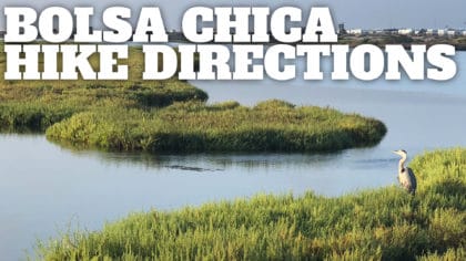
Bolsa Chica Ecological Reserve Hike
With great opportunities for wildlife spotting, this easy Bolsa Chica Ecological Reserve hike takes you on a scenic loop through the 1,300+ acres of protected wetlands just minutes from the Huntington Beach. The scenery includes seabird nesting islands, fresh and saltwater marsh, mudflats, active riparian river banks, and water. Over 200 species of birds have been spotted here, and it’s a popular stopover on bird migration routes. The hike is great for families with opportunities to shorten the route if 4.5 miles is too long.
Huntington Beach, CA - 4.5 miles, Easy
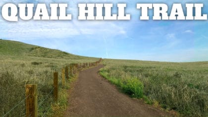
Quail Hill Trail
Quail Hill Trail is a 2-mile loop hike that offers expansive views goes through the Irvine Open Space Preserve, designated a Natural Landmark by both the State of California and the U.S. Department of the Interior. The family and beginner-friendly hike goes along the easy to follow Quail Hill Loop Trail, offers parking and bathrooms, interpretive displays, and wildlife viewing opportunities, all within minutes of suburban Irvine, CA.
Irvine, CA - 2 miles, Easy
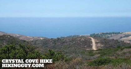
Crystal Cove Hike
This “best of” Crystal Cove hike takes you on a loop trail offering pristine coastal nature, ocean views, and well marked trails. You’ll take in the endangered native coastal sage scrub plant wilderness, which is how the area looked before it was developed, and then hike to heights where you’ll be able to see from the San Gabriel Mountains to Catalina. This hike is one of my favorites.
Laguna Beach, CA - 9 miles, Moderate

Upper Newport Bay Nature Preserve Hike
Nestled in the community of Newport Beach, the Bluff and Bay Trail Loop in Upper Newport Bay Nature Preserve offers great views of Upper Newport Bay and world-class wildlife spotting. The Upper Newport Bay Nature Preserve is home to some 200 bird species, including some endangered species, making it a top bird watching destination in the USA.
Newport Beach, CA - 3 miles, Easy
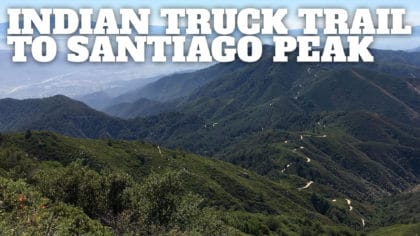
Hike Indian Truck Trail to Santiago Peak
The Indian Truck Trail offers an alternate way to hike Santiago Peak (Saddleback Mountain). It’s not a rustic single-track trail like the Santiago Peak hike from Lower Holy Jim Trail, but instead includes some wider Forest Service dirt roads (Indian Truck Trail is also known as forest road 5S01). You might see a few 4x4s or mountain bikes, but otherwise it’s very mellow. It’s a beautiful hike, so don’t let this stop you.
Corona, CA - 21 miles, Hard
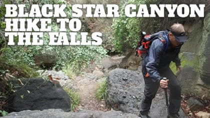
Hike Black Star Canyon Falls Trail
Hiking the Black Star Canyon trail is a local favorite for a reason. The trail follows Black Star Creek to Black Star Canyon Falls, and there’s a haunted history to ponder as you hike through this beautiful part of Black Star Canyon Wilderness Park. Hiking on the Black Star Canyon Trail can be a challenge, especially when it’s wet. This guide has everything you need to navigate the hike safely and get to the falls.
Silverado, CA - 7.1 miles, Moderate
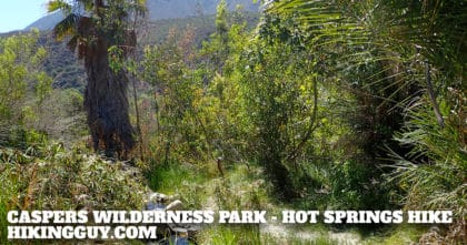
Caspers Wilderness Park – Hike San Juan Hot Springs
This is a a fun hike to San Juan Hot Springs, which is located in Caspers Wilderness Park, a lightly-visited, 8,000 acre, protected wilderness preserve in the foothills of the Santa Ana Mountains. The San Juan Hot Springs were first opened in the late 1800s as a full blown resort, complete with cabins, soaking tubs, and pools. Over the years they’ve closed and opened again, with the latest version being closed down in 1992. Today you can hike to San Juan Hot Springs, but whether you can go in them is up for debate (see the article for more). This hike to the hot springs can be done as an 10.5 mile out-and-back trip, or you can do a longer 14 mile loop that circles through the ridges in Caspers Wilderness Park, offering incredible views.
San Juan Capistrano, CA - 10.5 miles, Moderate
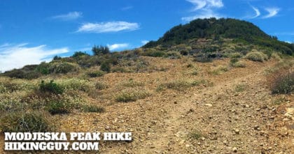
Modjeska Peak Hike
The Modjeska Peak hike is challenging – long, steep, and sometimes primitive. The hike climbs to the second highest point in Orange County, Modjeska Peak. Modjeska Peak, at 5,499 feet, is the lower peak in Saddleback Mountain. The highest peak (and other peak in Saddleback Mountain) is Santiago Peak. The actual summit is undeveloped and much nicer than nearby Santiago Peak. This is a challenging hike. Don’t try this hike without a good level of fitness.
Trabuco Canyon, CA - 15 miles, Hard
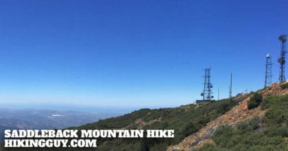
Saddleback Mountain Hike (Santiago Peak)
Hiking Saddleback Mountain takes you to the highest point in Orange County, Santiago Peak. It’s also the highest point in the Santa Ana mountains at 5,689 feet. This hike takes the scenic Holy Jim Trail, which is also the shortest route to the summit. This is a long and challenging hike. Don’t try this hike without a good level of fitness.
Corona, CA - 15.6 miles, Hard
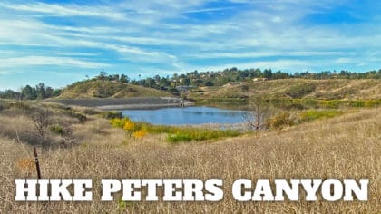
Peters Canyon Hike
This hike through Peters Canyon Regional Park is one of the most popular hikes in Orange County for a good reason. The hike has everything: well-maintained trails, climbs and flats, panoramic views, and wildlife spotting opportunities. This Peters Canyon hike takes you on a very-doable 2:30 hour loop of the park. Lots of side trails offer opportunities to make it shorter if you’d like.
Orange, CA - 5.9 miles, Moderate
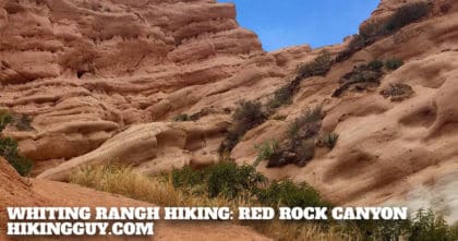
Whiting Ranch Hiking: Red Rock Canyon
There’s a few Whiting Ranch hiking options, but Red Rock Canyon is the most popular for a good reason. The gently climbing trail makes it way up a oak woodland canyon, eventually ending in a smooth red rock canyon like you’d see in Arizona (but unique to Orange County). Whiting Ranch Wilderness Park is rich with wildlife. I often see squirrels and lizards, and less often deer. The hike is mellow, easy, and is great for families.
Foothill Ranch, CA - 4.2 miles, Easy